Description of Survey Area:
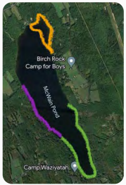
Approximately 473 acres, with a maximum depth of 42 feet but mostly between 15-25 feet throughout. Rocky sections in the northern area (orange on attached picture) are too shallow for boats. No public access to the pond, (although a priority for Maine Department of IF&W for smelt and other fishing), has allowed McWain to remain clean (divers noted much less trash along the bottom from where they usually dive). It should be stated that the lack of public access is a major factor in remaining invasive-free, as there are many places for invasive plants to take hold, but currently McWain has a healthy and diverse population of native aquatic plants. Substrate is sandy silt with rocks and boulders in the northern area, rocky along the purple surveyed area moving to leafy detritus in the southern end. Limited boat traffic.
 Survey Methods:
Snorkel, sea sled and boat survey
Dominant Species:
Spatterdock, pickerelweed and pondweed in very shallow sections. Fern pondweed, pipewort, burreed, bladderwort, native milfoil and common waterweed throughout. Along the northern purple marked area are more sections of dense patches of native milfoil but is not concerning. Also noted were crayfish and smallmouth bass.
Invasives found? GPS coordinates, management plan:
None
Orange section was rocky and shallow and snorkeled while the purple and green areas were surveyed via sea sled. Most notable were the more dense patches of native milfoil in the northern sections of the purple line, midway up the western shore. Otherwise a healthy and diverse population of native plants mixed all together. We want to stress that the patches of native milfoil are not a concern, but notable for future surveys.