From The Lakes Environmental Association Website
Water Quality: 2022
The average Secchi disk reading for 2022 was 6.3 meters, which falls into the moderately clear range. This value is higher (less clear) than the historic average of 7.0 meters.
Total phosphorus was low in 2022. The average value for surface samples was 4.2 parts per billion (ppb), which is below the threshold of concern of 10 ppb. These low levels of phosphorus usually mean that algal growth will be low, which is good for water clarity and dissolved oxygen levels.
Chlorophyll was also low in 2022. The average value for surface samples was 2.6 ppb. This is below the threshold of concern, and well within the range for Maine lakes. The relatively low levels of chlorophyll reflect the low phosphorus levels and mean that water clarity was not affected by algal growth.
Dissolved oxygen (DO) is important for fish and other aquatic organisms and for preventing the internal recycling of phosphorus from lake bottom sediments. In 2022, DO levels were generally good throughout most of the summer, with some decline noted at the bottom of the water column late in the season. This pattern is typical of lakes in the area.
Temperature readings showed typical seasonal variations. Surface temperatures increased steadily through the summer, peaking in July and August, while bottom temperatures remained cooler.
2022 Water-testing summary
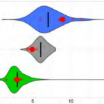
McWain Pond’s surface water chlorophyll (ppb), phosphorus (ppb), and Secchi depth (meters) data comparison Colored areas represent the long-term range of values, from minimum to maximum. Area thickness indicates frequency of measurements at that value. Area thickness increases as more measurements are reported at that value. The vertical black line represents the long-term average value. The large red dot represents 2022’s average value. The small red dots represent individual readings taken in 2022.
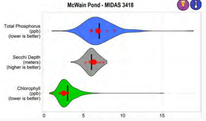
2022 Average vs. Long-Term Average
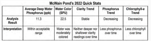
- Clarity: McWain Pond’s 2022 average water clarity was within the ‘moderately clear’ range. McWain Pond’s long-term clarity trend is stable, indicating neither deeper nor
shallower Secchi readings over time. - Chlorophyll: McWain Pond’s 2022 average chlorophyll concentration was within the ‘moderate’ range. McWain Pond’s long-term chlorophyll trend is decreasing, indicating that there is less chlorophyll in the water over time.
- Phosphorous: McWain Pond’s 2022 average phosphorus concentration was within the ‘moderate’ range. Deep water phosphorus values were not significantly above surface water phosphorus values indicating that phosphorus recycling was not an issue for McWain Pond in 2022. McWain Pond’s long-term total phosphorus trend is decreasing, indicating less phosphorus in the water over time. 2022 average vs. long-term average
McWain Pond Project
After a very successful volunteer-based survey of erosion sources within the Watershed, an implementation plan aimed at correcting the identified problems began. The project worked on numerous residential sites within the watershed and larger-scale conservation practices were also installed on Whiting Avenue, Camp McWain and Mill Hill Road.
Watershed Soils
2 percent of soils in the watershed are type A soils. Type A soils tend to be well drained sands, loams, and gravels. When vegetation is removed and the soil is exposed they can be susceptible to erosion. Because they are often coarse with ample pore space, there is low runoff potential and water will not usually pool on them. These soils can be good places to site leach fields or infiltrate stormwater from a home or residence.
3 percent of soils in the watershed are type B soils. B soils have moderate infiltration rates and fine to moderate texture and soil size. They are usually made up silts and
loams. Although not as well drained as A soils, they can also be good places to site leach fields and infiltrate stormwater.
71 percent of soils in the watershed are type C soils. C soils have low infiltration rates and typically have a layer that impedes the movement of water. These soils are made of sands, clays, and loams and are one of the most common soil types in western Maine.
2 percent of soils in the watershed are type D soils. D soils have a high runoff potential and very low infiltration rates. Soils with a high water table, clay or other impervious layer
near the surface are typically D soils. These soils are often associated with wetlands.
8 percent of soils in the watershed are type C/D solid. C/D soils are a mix of these two soil types. They have fairly high runoff potential and low infiltration rates and often pool water.
The remaining 15 percent of the watershed is taken up by the pond.